|
|
About Mesoamerica
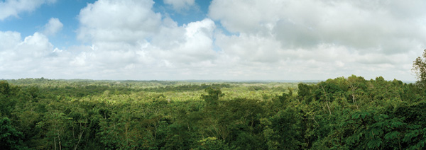
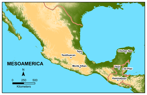
Mesoamerica is the region of Mexico and Central America defined in 1943 by Paul Kirchoff as the area of influence of Mexican cultures in the pre-Columbian era. In ancient times, Mesoamerica was home to advanced ancient civilizations - the Olmec, Maya, Zapotec, and Aztec. Spanish colonization left an indelible mark in the region, where Spanish continues to be spoken today. The geography features highland volcanoes and lowland tropical forest, which is facing the environmental challenges of the twenty-first century. The Maya Forest has endured many impacts related to human interaction over the past 10,000 years: the rise and fall of the Classic Maya civilization, the Spanish conquest, and the development of independent states. Deforestation: Mesoamerica is one of the most biodiverse regions on the planet with 17,000 plant species. Deforestation is a major concern: it is estimated that 80% of the area's original habitat has been cleared or severely modified. In 2005 the IUCN Red List noted that over 1,300 species were threatened; over half were plants. Comprising the forest, these plants are home to threatened animals like the jaguar and howler monkey. Population: Mesoamerica is home to about 140 million people. Half are children under 15 years old, representing a rapid growth rate that will double within the next 20 years. Much of the urban population suffers from malnutrition and poverty. A large proportion of the population is made up of rural farmers who depend on family labor. Focus: The Southern lowland region of Mexico, Guatemala, and Belize is the location of the Maya Forest, and home to the Maya Forest Gardeners. The El Pilar Forest Garden Network includes farmers in Belize and Guatemala.
About Belize Belize shares its borders with Mexico, Guatemala and the Caribbean Sea. As one of the smallest Central American countries, it covers 22,966 sq km (slightly smaller than the US state of Massachusetts). Belmopan, the capital, is located in the central part of the country. A former British colony known as British Honduras, Belize did not achieved independence until 1981. There are approximately 300,000 people in Belize, with a population growth rate of 2.207%. Ethnic groups include Mestizo (48.7%), Creole (24.9%), Maya (10.6%) and Garifuna (6.1%). English is the countrys official language, but many Belizeans speak Spanish, Mayan, Garifuna (Carib), and/or Belizean Creole as well. The small, essentially private-enterprise economy is dominated by tourism, followed by exports of marine products, citrus, cane sugar, bananas, and garments. Belizes climate is tropical, hot, and humid. The rainy season lasts from May to November. Hurricanes and flooding are natural dangers in Belize. Source: Central Intelligence Agency. (2008, November 6, 2008). "Belize." The World Factbook 2008. Retrieved November 2008, website. For more information, refer to The Government of Belize . About Guatemala Guatemala shares its borders with the North Pacific Ocean, El Salvador, Mexico, the Gulf of Honduras, Honduras and Belize. With a total of 108,890 sq km, it is the largest and most populous country in Central America. The capital is Guatemala City, located in the south-central part of the country. Guatemala achieved independence from Spain in 1821. There are approximately 13 million people living in Guatemala with a population growth rate of 2.11%. Ethnic groups include Mestizo and European (59.4%), K'iche 9.1%, Kaqchikel 8.4%, Mam 7.9%, Q'eqchi 6.3%, other Maya 8.6%. The population speaks Spanish (60%) and Amerindian languages 40%; Guatemala has 23 officially recognized Amerindian languages, including Quiche, Cakchiquel, Kekchi, Mam, Garifuna, and Xinca. Agriculture accounts for about 50% of the labor force while services are 35% and industry 15%. Guatemala uses two forms of currency, the quetzal (GTQ) and the US Dollar (USD). Guatemalas climate is tropical - hot and humid in the lowlands, and cool in the highlands. There are numerous volcanoes, occasional violent earthquakes, hurricanes and other tropical storms. Source: Central Intelligence Agency. (2008, November 6, 2008). "Guatemala." The World Factbook 2008. Retrieved November 2008, website. For more information, refer to The Government of Guatemala .
Copyright © 2007 - 20011 El Pilar Maya Forest Garden Network. |